Bradford Bypass
(Updated November 22, 2022) – This statement has been prepared in response to inquiries about our position on the Bradford Bypass.
What is the Bradford Bypass?
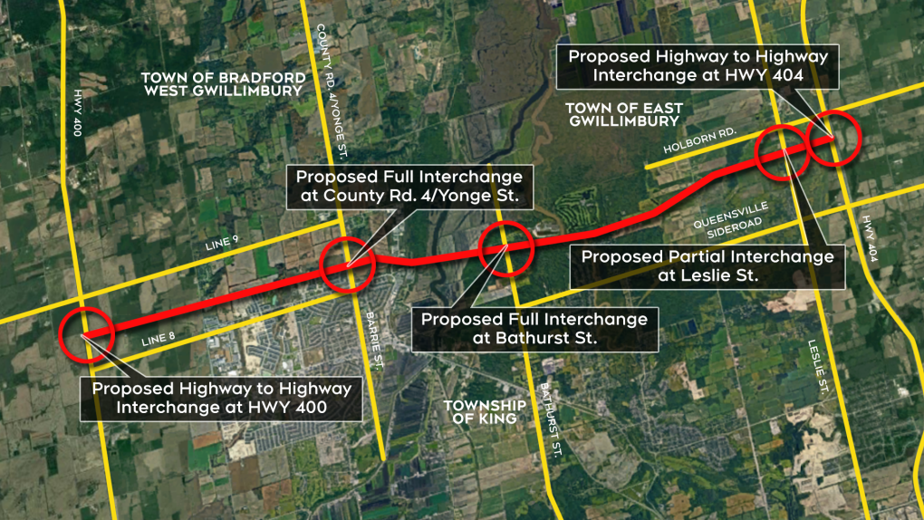
For those not familiar with the project, the Bradford Bypass is a proposed 16.2-kilometre long freeway connecting Highway 400 and Highway 404 in the Regional Municipality of York and County of Simcoe. The project-specific assessment of environmental impacts outlined in Ontario Regulation 697/21 for the project is currently being undertaken, with approval expected in 2023. A route planning study, Environmental Assessment and Recommended plan for the project were all previously approved in 2002.
The proposed highway would extend from Highway 400 between Lines 8 and 9 in Bradford West Gwillimbury, cross a small portion of King Township, and connect to Highway 404 between Queensville Sideroad and Holborn Road in East Gwillimbury.
Preliminary and Detailed Design
In September 2020, the Ontario Ministry of Transportation began a Preliminary Design Update Study, building on the approved 2002 Environmental Assessment for the Bradford Bypass. The anticipated design completion date is 2023.
If approved, the next stage in the project is to begin detailed design. The Ontario Ministry of Transportation is obligated to satisfy all Ministerial conditions, as well as to obtain all permits and approvals. As a provincial ministry, the Ministry of Transportation is exempt from obtaining a permit pursuant to the Authority’s Section 28 Regulation, Ontario Regulation 179/06 under the Conservation Authorities Act.
Unless required to consult with the Conservation Authority as a Condition of Approval by the Ministry of Environment Conservation and Parks, the Ministry of Transportation is under no obligation to seek further input at the detail design stage. While the Voluntary Project Review process is used by other Crown agencies, it has not (yet) been pursued by the Ministry of Transportaion for this project.
However, Ministry of Transportation has engaged and consulted with the Conservation Authority through the Preliminary Design stage, including notification and engagement at key milestone events such as the Notice of Study Commencement (2020), Public Information Centre #1 (2021) and the Regulatory Agency Committee Group meeting (2022). Direct communications and meetings continue to be undertaken to discuss the drainage modelling and watershed considerations within the Study Area as well as natural heritage features. It is the Conservation Authority’s goal to seek to ensure that the project is being planned in such a way as to minimize negative impacts to the natural environment, with the route designed to avoid the most sensitive areas, and provide appropriate mitigation, if avoidance is not possible.
Under Ontario Regulation 697/21, for the Bradford Bypass project, the Conservation Authority was provided the following documents for review and comment: Draft Early Works Report (2022) (Section 5 & 10, O. Reg. 697/21) and the associated Stormwater Management Plan (2022) (Section 7, O. Reg. 697/21), and Groundwater Protection and Well Monitoring Plan (2022) (Section 8, O. Reg. 697/21), as well as the Draft Environmental Conditions Report (Section 16, O. Reg. 697/21) for the overall project.
Next Steps for Future Consultation and Engagement During Detail Design and Construction
The Preliminary Design is anticipated to be completed in 2023. Ministry of Transportation has indicated that regardless of the delivery model (i.e., Detail Design), the Conservation Authority will continue to be engaged in consultation during the next stage of design.
About the Lake Simcoe Region Conservation Authority
The Lake Simcoe Region Conservation Authority is a local watershed management organization, incorporated under the Conservation Authorities Act (1946).
Since 1951, we have been dedicated to conserving, restoring and managing the Lake Simcoe watershed.
Our jurisdiction, which began in the East Holland River with five municipalities, has grown to include the entire Lake Simcoe watershed with the exception of the City of Orillia and the Upper Talbot River subwatershed.
We are governed by an 18-member Board of Directors, appointed within a four-year cycle by its 9 member municipalities. Each year, the Board of Directors elects a Chair and Vice Chair from among its 18 members.
About Our Watershed
The Lake Simcoe watershed is a 3,400 square kilometre area that sweeps across 20 municipalities, from the Oak Ridges Moraine in the south to the Oro Moraine in the north, through York and Durham Regions, Simcoe County and the cities of Kawartha Lakes, Barrie, and Orillia. The watershed is delineated by 18 major river systems and many smaller ones that flow through the landscape to the heart of the watershed: Lake Simcoe.
Media Contact:
Kristen Yemm,
Director Corporate Communications and Engagement
k.yemm@lsrca.on.ca
905-758-0108

