Lake Simcoe Shoreline Flooding
Shoreline flooding can occur under 2 typical scenarios:
High Lake Level Flooding
During the spring runoff (freshet), lake levels typically rise due to snowmelt and spring rains.
Lake Simcoe lake levels are managed by Parks Canada as part of the Trent Severn Waterway (TSW) system. The TSW system strives to follow an operational rule curve when managing lake levels. This is to allow for increased storage during the spring freshet followed by a gradual draw-down during the remainder of the year.
Some spring seasons see significant runoff due to large snowpack melt, spring rains or a combination of the two. During a high runoff year lake levels can rise above the rule curve and result in localized flooding along low lying areas adjacent to Lake Simcoe. This is most prevalent in the lower Cook’s Bay area of Lake Simcoe in the municipalities of Georgina, East Gwillimbury and Innisfil.
Significant disruption to people, services and property damage is typically limited during this type of flooding but can occur.
Storm Surge or Seiche Flooding
Lake Simcoe is a large inland lake approximately 722 km2 with wide distances between shorelines. Significant localized flooding and damage from a storm surge or seiche can occur on Lake Simcoe.
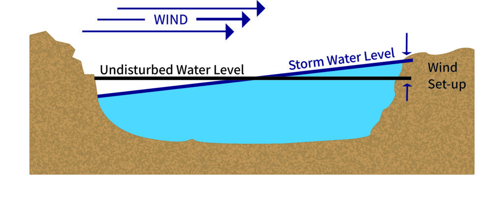
A storm surge or seiche results from high sustained winds from one direction that push the water level up at one end of the lake and make the level drop by a corresponding amount at the opposite end. A storm surge or a seiche condition can occur when there are significant sustained winds (typically greater than 40 km/h) over a lengthy period (24 to 72 hours). The higher the wind speed coupled with lengthy duration results in a larger storm surge. Please refer to the following illustration depicting a typical storm surge.

While Lake Simcoe does not typically experience large storm surges they can occur. The most recent significant event, which happened during the break-up of the ice sheet on Lake Simcoe in spring of 2018, resulted in shoreline damage on the eastern shoreline of Lake Simcoe.
Prevailing winds in the Lake Simcoe area typically range from north-westerly, westerly to south-westerly direction. The higher risk areas of Lake Simcoe are along the shorelines of the municipalities of Ramara, Brock and the northern shore of Georgina.
While rare, easterly winds can occur and are usually associated with a storm event which can place the shorelines of Oro-Medonte and Innisfil at potential risk to storm surge.
![]() Current Flood Status
Current Flood Status
Check the current flood status for the Lake Simcoe watershed:
![]() Flood Forecasting
Flood Forecasting
Lake Simcoe Region Conservation Authority maintains a flood forecasting and warning system to provide early warning of possible risks to people and property from flooding.
Read more about flood forecasting for Riverine (rivers and streams) and the Lake Simcoe Shoreline.
![]() Understand Your Risk
Understand Your Risk
Don’t wait until a flooding emergency happens to you… take the time now to understand your risk and prepare for a flood emergency.
