Our Watershed
Lake Simcoe Watershed
Our watershed is a vibrant and diverse habitat and a precious source of water. It’s also a centre for tourism and recreation — generating over $200 million annually for the local economy — as well as industry and agriculture. Our lives and that of its animals, plants and insects rely on its health. A healthy watershed supports sustainable communities.
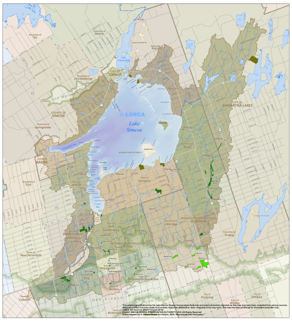
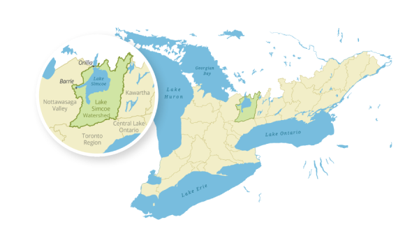
The Lake Simcoe watershed sweeps across 3,400 square kilometres and 20 municipal borders, from the Oak Ridges Moraine in the south to the Oro Moraine in the north, through York and Durham regions, Simcoe County and the cities of Kawartha Lakes, Barrie and Orillia. The lake itself covers 20 percent of the area and provides a source of safe drinking water to seven municipalities. There are over 500,000 residents in the watershed; 18 major river systems; 4,225 kilometres of creek, stream and tributary channels; and it’s home to 75 species of fish, with over 50 in the lake alone
What is a Watershed?
A watershed is an area of land drained by a river or stream. Similar to the branch of a tree, creeks empty into streams, which then empty into larger streams, eventually forming one main trunk, or river.
In our watershed, all of these rivers ultimately drain into Lake Simcoe. Within this system, everything is connected to everything else. In other words, actions which take place at the top of the system can and do affect those downstream.
Lake Simcoe Watershed Facts
Lake Simcoe wasn't always known as Lake Simcoe.
- The earliest known name for the lake was Ouentironk (oo-ent’-er-onk) the Huron word meaning “beautiful water”
- Early European settlers called it Lake Toronto
- In 1793 John Graves Simcoe the first Lieutenant-Governor of Upper Canada, renamed it Lake Simcoe in memory of his father, Captain John Simcoe of the Royal Navy
- Lake Simcoe’s bays were named for his father’s naval colleagues – Rear Admiral Richard Kempenfelt and Captain James Cook
Lake Simcoe wasn't always known as Lake Simcoe.
- Its surface area is 722 square kilometres
- If you walked around its shoreline, you would travel 240 kilometres
- Its average depth is 15 metres, but it gets as deep as 42 metres near the mouth of Kempenfelt Bay
- The lake is part of a much larger system known as the Trent-Severn Waterway
- Lake Simcoe water levels are managed by Parks Canada
Surrounding the lake, are river systems and lands that collect and drain water into Lake Simcoe. This area is the Lake Simcoe watershed.
- The Lake Simcoe watershed is a large region, about 3,400 square kilometres in size
- Its situated in our municipal communities of York Region, Durham Region, Simcoe County, Barrie, Orillia and Kawartha Lakes
- 18 major river systems (which include, streams, creek and tributaries) flow into Lake Simcoe and create the 18 distinct subwatersheds
- If you walked all the river and stream channels in the Lake Simcoe watershed, you would travel 4,225 kilometres
- Your shortest hike along a watercourse would be 68 km and your longest hike would be 766 km along the Beaver River
Topography determines the watershed boundary, because water flows from high ground to low ground.
- The Oak Ridges Moraine is the southern watershed divide – lands drain north off the moraine to Lake Simcoe and south off the moraine to Lake Ontario
- The Oro Moraine is the northern watershed divide
The lake, rivers, woodlands and meadows in the Lake Simcoe watershed are home to many species.
- Wetlands represent 13% of the watershed which is also equal to the amount of forests
- There are 75 species of fish in the watershed with over 50 different species found in the lake alone
- The yellow perch, whitefish and lake trout are very popular fish with anglers
- Unfortunately, there are over 32 species at risk in the watershed because their habitat is under pressure
- Red shouldered hawk, Eastern hog-nosed snake, Jefferson salamander and Southern flying squirrel are just some of the species that need our help
- Invasive species – plants and animals that are not natural to the Lake Simcoe watershed – are one reason why habitat is under pressure
- Common carp were the first invasive species to reach the lake in 1896 from a pond that overflowed in Newmarket
- Zebra mussels, rusty crayfish, Eurasian water milfoil, and garlic mustard are some of the invasive species that are causing concern today
The Lake Simcoe watershed is of course where many people live, work and play.
- Land use has changed a lot over time and today, 8% of the Lake Simcoe watershed is classified as urban land and 36% as agriculture
- 450,000 people live in the watershed
- Recreation from the lake generates over $200 million per year in the local economy, 80% of which is connected to ice fishing
- The watershed also provides a clean source of drinking water
We're connected to watersheds around the world because everyone lives in a watershed!
- The Lake Simcoe watershed is part of the Atlantic Ocean watershed
- Water travels from Lake Simcoe into Lake Couchiching and into Lake Huron’s Georgian Bay
- Water continues to flow through the Great Lakes – St. Lawrence seaway system and into the Atlantic Ocean
![]() Who to Contact
Who to Contact
Customer Service
✆ 905-895-1281
✆ 1-800-465-0437 Toll free
✉ info@LSRCA.on.ca


 Helpful Links